Pix4D viDoc RTK Rover
Pix4D viDoc RTK Rover
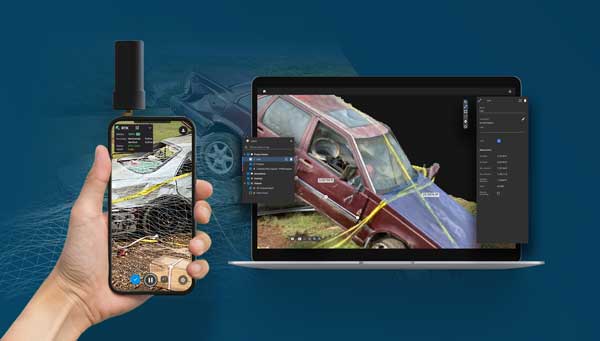
viDoc RTK Rover for iPad or Smartphone
- RTK positioning rover for 3D scanning
- Designed for iOS devices equipped with LiDAR sensors
- Works with other iOS and Android models
- Pairs with the PIX4Dcatch to geotag images of the 3D scan in real-time using NTRIP services
- Public safety and government agencies receive special pricing.
Other Pix4D Products
Why Buy from Aerial Metrics?
- Aerial Metrics is an authorized premium reseller of Pix4D hardware and software products with a specific focus on police, public safety and crash investigators.
- Public safety and government agency discounts on all Pix4D products.
- The exact same software, upgrades and support services that you receive when you purchase the software directly from Pix4D.
- Support from our team with over 8 years experience using Pix4D.
Why Pix4D?
As professionals with a long history in the information technology industry, we did not approach the selection of software lightly. We performed an extensive evaluation of available photogrammetry software using images from real world crash scenes in a wide range of lighting and weather conditions. We found that Pix4D was the most capable software for the specific requirements of crash investigation. In particular, we were impressed by its ability to process large datasets efficiently and the fine grained control the user has over the software. We found Pix4D provides us the ability to implement advanced techniques including combining day and night photography, and integrating ground photography with sUAS images that were taken at a different time. For this reason, Pix4D has quickly become the defacto standard for crash investigation photogrammetry and is being rapidly adopted worldwide. We anticipate that the community of crash investigators and reconstructionists using Pix4D will become an additional reason attracting police departments and consulting firms will adopt this platform.
Are there other options?
If you are expecting to process aerial photogrammetry on a regular basis, purchasing Pix4D will likely be your best option. However, the software price and training can be a barrier for smaller organizations or those processing small case loads. In these cases there are a few options you might wish to consider:
- Aerial Metrics Outsourced Crash Processing Service: For departments and organizations that do not have the volume of crash scenes to justify purchasing Pix4D and maintaining the skills to use it effectively, we offer a processing service that will provide the forensic mapping deliverables you need for your investigation and reconstruction work. Simply upload your images to us and we will handle the processing and scene markup for you. This service can be used either on a long term basis, or on a transitional basis as you implement your program and gain experience with the technology. Contact us for more details of this service.
- Monthly Licensing: If you have occasional need for Pix4D but can maintain the skills to be efficient with the software, you might consider the monthly licensing option. We would be pleased to discuss how we can provide you access to this option and offer you some additional value in supporting your operations. Contact us to discuss how to purchase a monthly license through Aerial Metrics.