  • Home
  • Crash Investigation
    • Benefits
    • Case Studies
    • Performance Comparison
  • Services
    • UAS Unit Startup
    • Training Classes
      • Part 107 Knowledge Test Training
      • sUAS Crash Investigation Remote Pilot
      • Crash Investigation Aerial Photogrammetrist
    • Image Processing, Analysis and Storage
    • Pix4D Software for Crash Investigation
  • Media
  • Resources
    • Public Safety UAS Deployments
    • Latest News
    • Map Tools
    • External Links
  • About
    • Login
    • About Us
    • Contact

Aerial Metrics

Crash Investigation Case Studies

Single vehicle 10-50, Barrington Middle School Station Campus, Barrington, IL - May 9, 2016
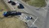
Three vehicle 10-50, N. Darrell & W. Roberts Road, Port Barrington, IL - March 11, 2016
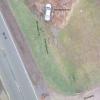
Single vehicle 10-50, Rt. 12 & Case Rd., Wauconda, IL - November 26, 2015

Aerial Metrics is a premium reseller of Pix4D's Pix4DMapper. The Pix4D cost from Aerial Metrics is the same as from all other resellers but with additional value added items.  Please see details at Pix4D Cost.